
Anahulu River sonic Tracking Project
SONIC TRACKING PROJECT
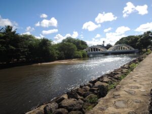
The Anahulu River (also called Anahulu Stream) is the longest watercourse on the island of Oahu in the It is 7.1 miles (11.4 km) long. It is formed on the western side of the northern Koolau Range approximately 7 miles (11 km) northeast of Wahiawa by the confluence of Kawainui and Kawai’iki streams, both perennial. It flows west-northwest descending through Kawailoa Gulch, then empties into the eastern end of Waialua Bay at Hale’iwa. It encompasses a watershed of approximately 16 square miles (41 km2) and a 100-year peak discharge of 16,200 ft3/s (459 m³/s).
Archeological evidence indicates that the valley of the river near its mouth was the site of ancient Hawaiian villages. The river valley was abandoned but was later repopulated in the early 19th century, partly as the result of a policy by King Kamehameha I to grow food to support his military expeditions. The policy included the development of irrigated terraces. In 1832 U.S. Protestant missionaries John Emerson and his wife Ursula Sophia circumnavigated Oahu and put in at the mouth of the river, located at 21°35′40″N 158°6′15″W. At the village of Hale’iwa (from hale (home) of the iwa (frigate bird)), they were welcomed by Chief La?anui and established the Liliuokalani Church in the village.
In the later 19th century the village of Hale?iwa and the surrounding river valley became a popular summer vacation destination for the Hawaiian monarchs. The first hotel was built along the river by businessman Benjamin Dillingham, who also built Oahu Railroad from Honolulu to the north shore in 1898. The railroad and hotel made the river valley a popular vacation spot.
The Anahulu River is currently a very popular destination for tourist and residents to do kayaking and paddle boarding. The river is navigable from its mouth up about 1.7 km where some large boulders make it difficult to paddle. Over the last 15 years (and probably before that), since the population has increased, Hawaiian green turtle (honu) have been entering the river and moving into its quiet waters for extended periods of time. If one watches the shallow waters near the entrance of the river one can often see honu swimming into or out of the river. It seems that honu traffic is heaviest during the morning going out and during the evening coming into the river. We do not know exactly what the honu do while in the river, how long they spend in the river and when they are prone to move into or out of the river.
In order to better understand the river habitat use by the honu, we have begun a study to track the honu’s movements using hypersonic tags and in-water receiving stations to pick up signals from the tags. The receivers are moored in the river and the sonic tags are attached to the carapace (dorsal shell) of the turtles using polyester resin and glass cloth. So far we have deployed 15 sonic tags and believe that having more tags in the river may cause interference and problems with sensing the tags presence. The tags were attached to the turtles on October 25 – 27, 2016 and since that time the transmitters and receivers have been communicating whenever the turtles are in the river. The data from each of the 4 stations were downloaded on November 16th and there was data from each of the 15 turtles present. Below is a link to the final report on the project.
The slide show below will give you some idea of the way we placed the sonic receivers and how we have attached the sonic tags (transmitters) to the turtles.